Using Climate Maps
What Do You Know about Maps?
فرمت کتاب
audiobook
تاریخ انتشار
2018
Lexile Score
780
Reading Level
3-4
ATOS
4.7
Interest Level
4-8(MG)
نویسنده
Intuitiveشابک
9781541515833
کتاب های مرتبط


- اطلاعات
- نقد و بررسی
- دیدگاه کاربران
نقد و بررسی
November 1, 2016
Gr 4-7-These volumes introduce readers to the wonder and value of maps. Their strongest elements are the well-chosen examples of different types of maps found in each. Each book defines a map type; summarizes its developmental history; discusses basic cartographic terms, such as scale, legend, and compass roses; and explains how it depicts important data with real-world applications. Chapters combine clear prose and examples on almost every page to describe and illustrate cartographic and informational concepts. A concluding "Are You a Whiz at...?" activity requires readers to use maps to complete several steps in order to plan a trip or adventure. Appealing photos of people and places are a plus.
Copyright 2016 School Library Journal, LLC Used with permission.
February 15, 2017
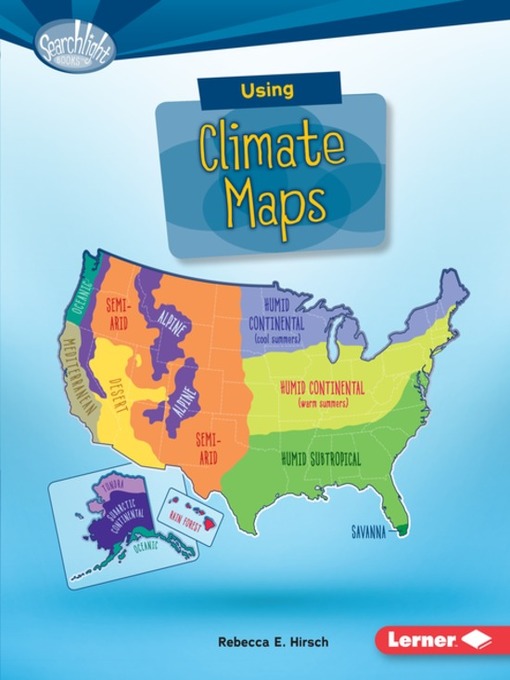
Grades 3-5 Whether pulling up a map on your phone or going old-school and referencing a travel guide, neither will be much use without the skills to interpret it. The books in the Searchlight Books: What Do You Know about Maps? series set out to teach readers how to navigate a wide range of maps and point out just why they might want to. Each introduces common map elements, such as scale, keys, and the compass rose, as it shows a specific type of map at work. Climate Maps demonstrates how different colors might be used on a map to indicate a region's average temperature or rainfall, taking care to differentiate between climate and weather. Clean layouts nicely balance colorful graphics and white space, and each volume ends with an exercise to test readers' newfound map skills.(Reprinted with permission of Booklist, copyright 2017, American Library Association.)


دیدگاه کاربران